Level 1
Weather per field
Weather-based work windows that prioritize fields for timing and efficiency. No sensors or new equipment required – just smarter scheduling for spraying, fertilizing, and irrigation.

Agdir Farm helps you make data-driven decisions for healthier crops and higher yields. By combining precision irrigation with real-time weather data, satellite imagery, and soil sensors, you gain full insight into your fields. Monitor root-zone conditions, prevent over- and under-irrigation, and respond faster to changing conditions — all from one integrated system.
Sensor data is available through supported integrations (sensor sold separately). Check our list of compatible sensors. Satellite analysis is included in Plus and Professional plans.
Smarter decisions and lower costs - without investing in new machinery.

Agdir Farm helps you map, monitor and manage your field efficiently, giving you a complete overview of your farm. Say goodbye to scattered notes and lost information. It's easy to use and will give you a better overview of your fields!
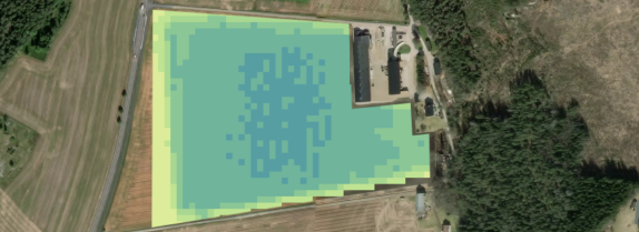
Maximize crop yields through precision farming. Base your decisions on satellite imagery and advanced analytics. Discover how our insights can boost your yields and optimize your agricultural practices for greater efficiency and productivity. Harness the full potential of precision agriculture!

Get precise, field-specific weather forecasts with Agdir Farm. Access real-time updates and predictive analytics that enable you to plan your farming activities confidently and avoid unexpected disruptions. Stay informed and make smarter decisions with Agdir Farm!

With Agdir Farm Inventory, you always have a clear overview of what you have on the farm – such as fertilizers and plant protection products – and what you need. This saves you time, frustration, and unnecessary costs. Always updated, always prepared.
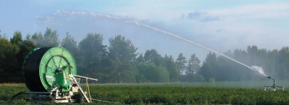
The amount of water in the soil is crucial to how well your crops grow. All fruits and vegetables need water, and it could be difficult to know exactly how much water the crops need. Avoid over or under irrigation with Agdir Farm, and ensure healthier crops. Start improving your irrigation strategy today.
Agdir combines sensor data with weather forecasts and satellite imagery to turn raw measurements into practical advice for each field. Instead of just showing numbers, the system recommends when and how to irrigate — transforming data into real decision support.
Precision farming isn’t about owning the most sensors or the most expensive equipment – it’s about making better decisions, more often, and with less uncertainty. Agdir combines weather, satellite data, optional sensors, and per-field journals to turn data into actionable recommendations: when irrigation has the biggest effect, where fertilization pays off most, and which order saves time and fuel. For family farms in generational transition, this means data-driven decisions that can be shared, learned, and passed on – less silent knowledge, more structured precision.
Agdir combines weather, satellite, (optional) sensor, and journal data at field level. This gives concrete answers to three key questions: Where should action be taken? When is the timing safe and effective? How is it documented? This way, precision becomes a working habit – not a purchasing project.
Weather-based work windows that prioritize fields for timing and efficiency. No sensors or new equipment required – just smarter scheduling for spraying, fertilizing, and irrigation.
See biomass differences within fields. Focus effort where it matters most. Still no new machinery – just improved order and targeting.
Compare actions with weather context and outcomes. When did early fertilization work best? When did shorter irrigation intervals make a difference? Build precision season by season.
Soil moisture sensors on sandy soil, temperature sensors for spray windows. Not everywhere – only where uncertainty costs the most.
Connect GPS and variable rate dosing once the gain is proven and the investment makes sense.
When spraying, fertilizing, and irrigation happen under optimal conditions, efficiency per treatment increases. Less input, better results.
Satellite imagery shows where extra effort pays off and where standard treatment is enough. Fewer unnecessary applications.
The journal, combined with weather context, builds reusable insight. “This is what worked last time” becomes concrete and traceable.
Everyone sees the same recommendations per field. Less debate about what to do – more focus on how to do it.
Red zones on the satellite map get priority for additional fertilization – but only if weather conditions allow nutrient uptake. This avoids waste on areas that don’t need or can’t use it.
When degree days rise quickly and soil moisture readings drop, Agdir recommends shorter, more frequent irrigation – but only on the fields that truly need it.
Field-specific wind and temperature readings provide safer spray windows. Less drift, better results, and documented compliance.
In generational transitions, precision is about making experience visible. When decision logic lives in the system – “we spray field A before B because satellite shows X and weather window Y” – knowledge can be transferred without depending on one person. The successor sees not only what was done, but why.
Precision farming starts with better decisions, not new machinery. Agdir unites weather, satellite, sensors, and journals per field to make smarter choices easier and more consistent. For family farms in transition, this means shareable insight, smoother handovers, and increased profitability year after year.Start your precision journey in Agdir today: map your fields, activate weather and satellite, structure your journal – and see how data turns into better performance this very season.